Destination Sardinia
  • The island
    • History
    • Regions
    • Points of interest
    • Climate
    • Geography
    • Nature
    • Beaches
    • Festivals
    • Language
  • Travel time
  • Arrival
    • Car/Motorbike
    • Ferry
    • Plane
    • Train
  • Accommodation
    • Hotel
    • Bed and Breakfast
    • Holiday flat
    • Holiday house
    • Agriturismo
    • Camping
    • Campervan
  • Food and Drinks
    • Eating out
    • Self-catering
    • Culinary specialities
  • Mobility
    • Car
    • Motorbike
    • Bike
    • Bus
    • Railway
    • Ship and boat
  • Points of interest
  • Activities
    • Hiking
    • – Tour tips
    • Climbing
    • Surfing
    • Diving and snorkelling
    • Fishing
    • Riding
  • Pract. tips
    • Literature
    • Maps
    • Language
    • Post and telephone
    • Internet
    • Opening hours
    • Photography
    • Children
    • Health
    • Dogs and pets
    • Souvenirs
    • Weblinks
  • Menu Menu
  • The island
    • The island
    • History
    • Regions
      • Anglona/Turritano
      • Arborea
      • Barbagia
      • Baronia
      • Cagliari region
      • Campidano
      • Gallura
      • Iglesiente/Sulcis
      • Logudoro/Meilogu
      • Nurra
      • Ogliastra
      • Planargia
      • Quirra/Sarrabus
      • Sarcidano/Marmilla
    • Points of interest
      • Alghero
      • Alghero, north
      • Archipelago di La Maddalena
      • Ardara / Sant‘ Antioco di Bisarcio
      • Argentiera / Grotta di Nettuno
      • Aritzo
      • Arzachena and surroundings
      • Bosa
      • Burgos and surroundings
      • Cagliari
      • Capo Comino / Spiaggia di Berchida
      • Carbonia and Monte Sirai
      • Castelsardo and surroundings
      • Churches near Sassari
      • Costa del Sud
      • Costa Rei and hinterland
      • Costa Smeralda, Palau and surroundings
      • Costa Verde
      • Fonni and surroundings
      • Fordongianus
      • Giara di Gesturi
      • Gola su Gorroppu / Codula di Luna
      • Gulf of Orosei
      • Iglesias and Grotta di San Giovanni
      • Ingurtosu
      • Isola di Sant’Antioco
      • Is Pirois, Funtana Coberta, Pranu Muteddu
      • Ittireddu
      • Macomer and surroundings
      • Montiferru-Area
      • Nebida, Masua and Buggerru
      • Nora
      • Nuoro and surroundings
      • Nuraghe Arrubiu
      • Nuraghe Iloi and surroundings
      • Nuraghe Losa
      • Nuraghe Santu Antine / Sant‘ Andria Priu
      • Nuraghe Su Nuraxi
      • Olbia and surroundings
      • Orgosolo
      • Oristano / Sinis-Peninsula / Tharros
      • Orosei and Biderosa Nature Park
      • Orosei’s hinterland
      • Osini and Ulassai
      • Ozieri
      • Porto Torres and Monte d’Accoddi
      • Posada and Surroundings
      • Sadali
      • Santa Cristina
      • Santa Teresa / Capo Testa
      • Santa Vittoria
      • Sassari and Noeddale Necropolis
      • Sedini and Martis
      • Siniscola and Surroundings
      • Stintino and Isola Asinara
      • Su Golgo, Sa Pedra Longa, Santa Maria Navarrese
      • Su Romanzesu and Nuraghe Loelle
      • Su Tempiesu and Nuraghe Noddule
      • Tempio di Antas
      • Tempio Pausania and Surroundings
      • Tonara, Sorgono, San Mauro, Menhire Biru ‚e Concas
      • Trenino Verde (Arbatax-Sadali)
    • Climate
    • Geography
    • Nature
    • Beaches
    • Festivals
    • Language
  • Travel time
  • Arrival
    • Arrival
    • Car/Motorbike
    • Ferry
    • Plane
    • Train
  • Accommodation
    • Accommodation
    • Hotel
    • Campervan
    • Agriturismo
    • Bed and Breakfast
    • Camping
    • Holiday house
    • Holiday flat
  • Food and Drinks
    • Food and Drinks
    • Eating out
    • Self-catering
    • Culinary specialities
  • Mobility
    • Mobility
    • Car
    • Motorbike
    • Bike
    • Bus
    • Railway
    • Ship and boat
  • Points of interest
    • Alghero
    • Alghero, north
    • Archipelago di La Maddalena
    • Ardara / Sant‘ Antioco di Bisarcio
    • Argentiera / Grotta di Nettuno
    • Aritzo
    • Arzachena and surroundings
    • Bosa
    • Burgos and surroundings
    • Cagliari
    • Capo Comino / Spiaggia di Berchida
    • Carbonia and Monte Sirai
    • Castelsardo and surroundings
    • Churches near Sassari
    • Costa del Sud
    • Costa Rei and hinterland
    • Costa Smeralda, Palau and surroundings
    • Costa Verde
    • Fonni and surroundings
    • Fordongianus
    • Giara di Gesturi
    • Gola su Gorroppu / Codula di Luna
    • Gulf of Orosei
    • Iglesias and Grotta di San Giovanni
    • Ingurtosu
    • Isola di Sant’Antioco
    • Is Pirois, Funtana Coberta, Pranu Muteddu
    • Ittireddu
    • Macomer and surroundings
    • Montiferru-Area
    • Nebida, Masua and Buggerru
    • Nora
    • Nuoro and surroundings
    • Nuraghe Arrubiu
    • Nuraghe Iloi and surroundings
    • Nuraghe Losa
    • Nuraghe Santu Antine / Sant‘ Andria Priu
    • Nuraghe Su Nuraxi
    • Olbia and surroundings
    • Orgosolo
    • Oristano / Sinis-Peninsula / Tharros
    • Orosei and Biderosa Nature Park
    • Orosei’s hinterland
    • Osini and Ulassai
    • Ozieri
    • Porto Torres and Monte d’Accoddi
    • Posada and Surroundings
    • Sadali
    • Santa Cristina
    • Santa Teresa / Capo Testa
    • Santa Vittoria
    • Sassari and Noeddale Necropolis
    • Sedini and Martis
    • Siniscola and Surroundings
    • Stintino and Isola Asinara
    • Su Golgo, Sa Pedra Longa, Santa Maria Navarrese
    • Su Romanzesu and Nuraghe Loelle
    • Su Tempiesu and Nuraghe Noddule
    • Tempio di Antas
    • Tempio Pausania and Surroundings
    • Tonara, Sorgono, San Mauro, Menhire Biru ‚e Concas
    • Trenino Verde (Arbatax-Sadali)
  • Activities
    • Activities
    • Hiking
    • – Tour tips
    • Climbing
    • Surfing
    • Diving and snorkelling
    • Fishing
    • Riding
  • practical tips
    • practical tips
    • Literature
    • Maps
    • Language
    • Post and telephone
    • Internet
    • Opening hours
    • Photography
    • Children
    • Health
    • Dogs and pets
    • Souvenirs
    • Weblinks
  • Search…
You are here: Home1 / The island2 / Points of interest3 / Iglesias and Grotta di San Giovanni

deutsch

Iglesias and Grotta di San Giovanni

map of Iglesias and surroundings

Iglesias

Iglesias, Piazza Sella
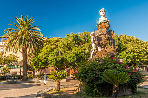
For a city tour, it’s best to park near Piazza Quintino Sella (photo) and walk into the old town.

The area has been inhabited since ancient times. By the time of the Roman Empire, the local silver deposits were already known.
In the 13th century, the south of Sardinia was under Pisan rule. The fleet admiral Count Ugolino della Gherardesca founded the city under the name Villa di Chiesa, Latin Villa Ecclesiae (Church City).
The mining of silver, zinc, and lead quickly enriched the city, causing it to flourish and gain the right to mint coins.

City wall and Castello Salvaterra

Iglesias Castello

Soon after its establishment, a city wall with numerous towers was constructed.
To the northwest of Piazza Sella, a footpath winds its way along the remnants of the fortification, leading up to the remains of Castello Salvaterra. From there, you can enjoy a pleasant view over the rooftops of the old town.

When the Spaniards conquered Sardinia, Villa di Chiesa became the first Sardinian city to fall into the hands of the Aragonese.
Although the Pisans managed to withstand the siege for 7 months, they ultimately surrendered in 1324.

The Old Town

Piazza Lamarmora

The historical center is relatively small and can be easily explored on foot.
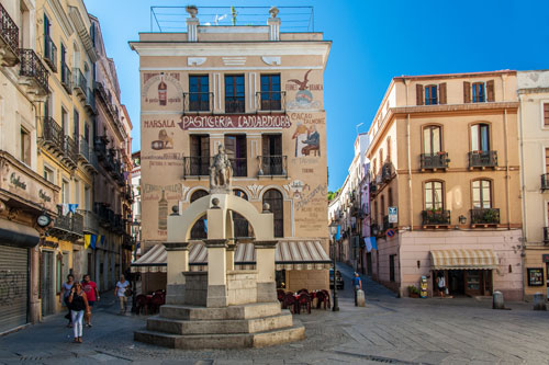
Many of the old bourgeois houses and palaces have been lovingly restored.
In the photo, you can see Piazza Lamarmora.
The narrow, shaded streets invite you to stroll with their small shops. For resting, there are numerous cafes and bars.

Santa Chiara Cathedral

Iglesias Kathedrale Santa Chiara

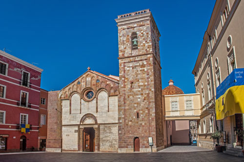
The largest church in Iglesias is the Santa Chiara Cathedral located on Piazza Municipio. The cathedral was built from 1284 to 1288, but only the entrance facade and the bell tower remain from that time. The interior was remodeled in the 16th century in the Gothic style of the Catalans.
Also situated in the square are the Episcopal Palace and the Town Hall.

The name Villa di Chiesa/Villa Ecclesiae derives both from the many churches built by the very religious inhabitants and from the strong power exerted here by the church.
After the conquest by the Aragonese, with the spread of the Spanish language, the present name Iglesias (Churches) emerged.

Iglesias, Chiesa San Francesco

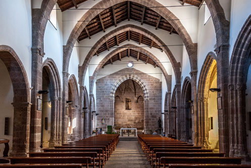
On your stroll through the old town, you can visit several other churches. The photo shows the interior of Chiesa San Francesco from the 14th century.

After the Spanish conquest, Iglesias began to decline.
It wasn’t until the Piedmontese period, starting from 1848, that the mining engineer and later minister Quintino Sella initiated a resurgence in mining.
Iglesias benefited from the increasing demand for raw materials during industrialization.
Under Mussolini, there was renewed investment in mining to make Italy independent of raw material imports. This initially led to a short-lived boom, but by the 1950s, ore extraction became uneconomical, and most mines had to close.

Grotta di San Giovanni

Grotta di San Giovanni
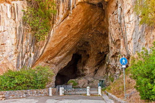
The cave is located approximately 12 km from Iglesias. First, head to Domusnovas, where the cave is well signposted in the village.
You can park directly in front of the cave entrance.
There is a small restaurant nearby, and a little further up is the church of San Giovanni. Locals often gather there for picnics under the shade of the trees.

Grotta di San Giovanni
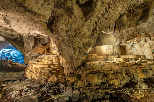
Until 1999, it was still permitted to drive through the cave with your own car. However, this led to an increasing pollution of the magnificent stalactites due to exhaust fumes. As a result, vehicular access was prohibited.
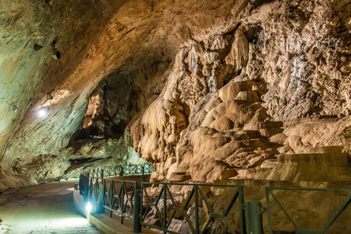
Today, you can comfortably walk along the road on foot. Next to it flows the Riu San Giovanni. The water level varies depending on the season, and in summer, the river only emerges from outside the cave.

Grotta di San GiovanniThe cave is fully illuminated. For photography, I recommend using a tripod. Flash photography won’t be very effective here.
The path through the cave is about 700 m long, and you’ll reach the exit in 10-15 minutes.
The road was constructed in the 19th century to transport minerals extracted from the large Sa Duchessa mine via a shorter route.
At the northern exit, there’s a small picnic area. From here, you can embark on hikes into the remote mountain landscape. Remnants of mining activities can still be found everywhere. Hobby geologists and mineral collectors, in particular, will find joy in exploring this area.

www.grottasangiovanni.com

Search Search

Instagram

Follow us

Legal Notice

Legal Notice

Privacy Policy

Privacy Policy

Contact

Contact

© Copyright Traumziel-Sardinien 2009-2026
Scroll to top Scroll to top Scroll to top