![]()
Fonni and surroundings
map of Fonni and surroundings with the marked sights
Fonni
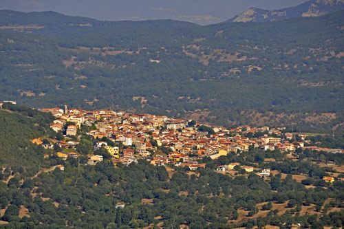
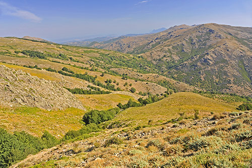
Fonni is the highest located town in Sardinia. The mountain village has around 4000 inhabitants and sits 1000 meters above sea level. The drive to Fonni, while scenic, is relatively unspectacular as the area appears rather hilly.
The historic center ascends along a steep slope. The streets are partially very narrow, making turning with a car repeatedly challenging. Therefore, it’s best to leave your vehicle further down.
Outside the center, modern buildings dominate the townscape. Fonni is very suitable as a starting point for hikes in the Gennargentu area. Even a modest winter tourism has established itself.
The inhabitants mainly live from pastoral farming on the surrounding mountain slopes.
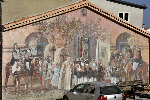
On many walls, beautiful paintings – called murales – are displayed.
These paintings differ greatly from the famous murals in Orgosolo. While there, mainly political messages adorn the house walls, here in Fonni, they are very realistically held images of rural life in the mountains and the religious festivals of the villagers (photo).
Many murals are located off the main street, so it’s worth taking a leisurely stroll through the village.
Monastery and Basilica Nostra Signora dei Martiri
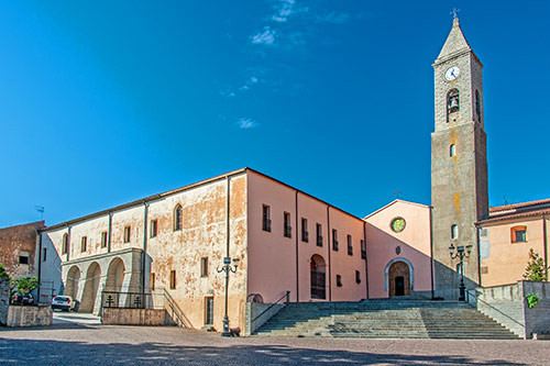 Above Piazza Europa is a Franciscan monastery, which, together with the associated church, is one of the most important pilgrimage sites in Sardinia.
In 1610, the local family of Don Stefano Melis donated the land to the Franciscans for construction. The Melis family crest is still displayed above the entrance to the church.
After several interruptions, the monastery and church were completed around 1633.
The church was originally dedicated to the Holy Trinity.
In 1702, one of the three church chapels was demolished, and in its place, another church was built by 1706, dedicated to the Virgin of the Martyrs.
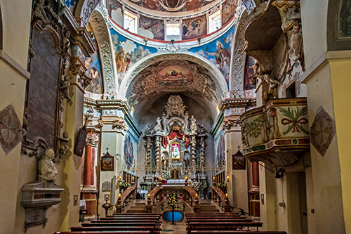
The interior of the church is adorned with more baroque splendor than one would expect in a remote mountain village.
The statue of the Madonna of the Martyrs stands above the altar. It was crafted in Rome in the 17th century, using, according to tradition, crushed bones of martyrs and other relics. The image of the Madonna was intended to bestow even greater significance upon the church. In honor of the Madonna, a large festival takes place in Fonni every year – the Sagra della Madonna dei Martiri. It lasts from the first Sunday in June until the following Tuesday. During this time, the statue is carried through the village in a procession. For interested visitors, this festival is a great opportunity to see the traditional costumes of the inhabitants.
The Christianization of Sardinia was a very challenging process due to the ancient traditions and rituals. In the crypt of the church, the work of the missionaries is depicted on some beautiful frescoes.
Drive to Monte Spada and Bruncu Spina
When driving from Fonni on the SP 7 heading south, you’ll venture further into the Gennargentu area. After about 5 km, a road branches off to the left, which then splits again after 1 km.
To the right leads to Bruncu Spina, and to the left leads to Monte Spada.
In the wooded slopes, the nature park “Donnortei” has been established, which is worth a short visit.
On the treeless northern slope of Monte Spada, a small ski lift is opened after sufficient snowfall. This slope is very suitable for children and beginners.
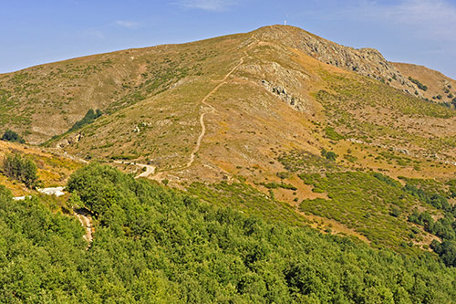 Monte Spada is Fonni’s local mountain and can be easily climbed. The probably easiest route starts on the road to Bruncu Spina, where a wide path leads directly to the summit cross. (photo)
From the top, you have a beautiful view of the village and the surrounding mountain slopes.
Although the Gennargentu Massif is the highest mountain range in Sardinia, it does not appear rugged or forbidding. The gently rounded peaks are excellent for hiking. Even in the height of summer, it is usually pleasantly cool up here.
The ski lift at Bruncu Spina
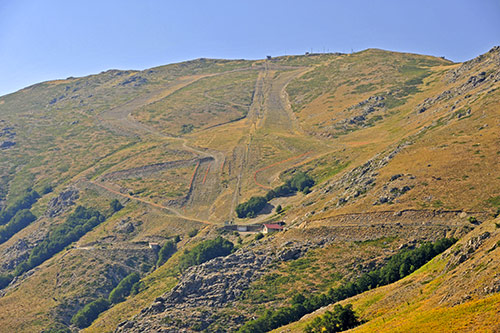
The ski lift at Bruncu SpinaThe turnoff to Bruncu Spina winds through numerous curves for 10 km through a barren and lonely high mountain landscape. At the end of the road, there is a parking lot and a small lift station.
The ski lift is famous throughout Sardinia – it is the only slope that offers sports descents in winter.
During the milder seasons, you can undertake wonderful hikes up here. One trail leads from the valley station up to the summit of Bruncu Spina, which at 1829 m is the second highest peak in Sardinia.
From there, you can traverse several mountain ridges to Punta La Marmora (1834 m), the highest mountain in Sardinia. On very clear days, it’s said that one can overlook the entire island from the top.
Nuragic Complex of Gremanu
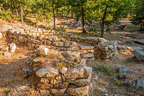
The complex covers an area of about 7 hectares in total. It consists of the remains of a nuragic settlement, a temple precinct, and a well system.
Excavations began in 1989 and lasted until the late 1990s. An elaborate system of wells, captured springs, channels, and basins for ritual washings was found in the upper area.
Here is also the only known aqueduct from the Nuragic era.
Gremanu likely originated from the 15th century BC on an existing settlement.
Around 1000 BC, no more fortified nuraghes were built; instead, settlements arose near temples with wells and sacred springs dedicated to water deities.

The temple precinct of Gremanu is surrounded by a wall and divided into several areas.
Inside, there is a rectangular Megaron temple and a round nuraghe-shaped temple. The latter served not only as a temple but also as a foundry for the bronze statuettes found here.
These statuettes were presumably offerings to the gods, along with the bronze swords discovered.
Justice was also administered in the temple, with the gods judging the guilt of the accused. Ancient sources report that the accused had to dip his eyes in water. If his sight improved afterward, he was innocent – if he became blind, he was guilty.
How to get there: Gremanu is difficult to find in the terrain because the area consists of pastureland intersected by wire fences. Additionally, there are currently no signs at all.
Turn off approximately at km 28 from the SS 389 towards “Fonni/Passo Caravai” and immediately after the exit onto the “old” SP 2 towards “Pratobello/Orgosolo”. After about 600 m, a path into the valley begins on the left side of the road behind a gate. After crossing the stream, keep left heading south, and soon you’ll see the walls of the temple precinct. (see map)
The Giants’ tombs of Madau
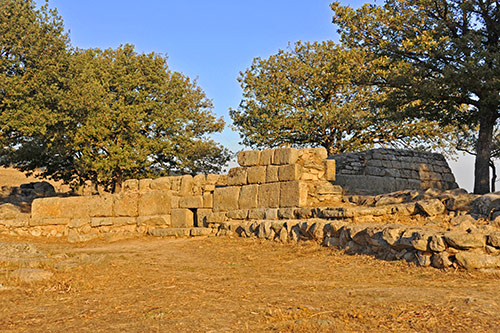
The burial site belonged to the nuragic settlement of Gremanu.
It consists of a total of five tombs, two of which are still very well preserved.
Four of the tombs are located side by side in the shape of an amphitheater facing the Gennargentu Massif.
The fifth tomb stands about 500 meters away to the northwest.
Excavations took place here from 1982 to 1984, and the site was partially restored. Ceramic objects and a bronze bracelet were found during these excavations.
Based on these finds, the site was dated to the end of the Bronze Age, around the 14th – 13th century BC.
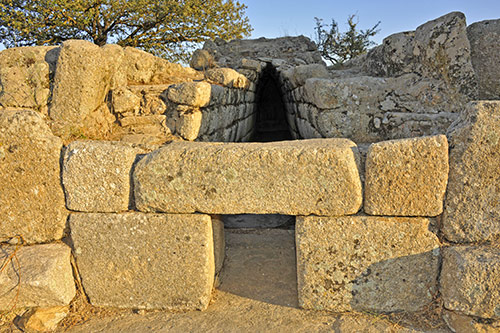
At the two nearly intact tombs, one can easily discern the construction method. A curved wall formed the front, with the entrance situated centrally. Beyond lies a corridor stretching approximately 20 meters, lined with large stone slabs on both sides. Unlike other Giants’ tombs in Sardinia, such as Coddu Vecchiu or S’Ena e Tomes, where large stone slabs were used for covering, in Madau, smaller stones were employed to create a corbelled vault for the corridor. This unique architectural feature was further enhanced with layers of earth and worked stones.
How to get there: Madau is situated approximately 1.6 km north of Gremanu (see map). Similar to Gremanu, it is accessible not from the SS 389 highway, but solely from the “old” SP 2, running parallel. The site is easily identifiable from the roadside.