![]()
Isola di Sant’Antioco
map of the island Sant’Antioco
Sant’Antioco
The main town of the island was already established under the Punics as an important port city. From this time also dates the 5 km long dam, which connects Sant’Antioco with the main island of Sardinia.
Later, the entire island came under Roman rule and was continuously inhabited until the Middle Ages. Due to frequent pirate attacks from the 8th century onwards, the city was abandoned and the inhabitants retreated to the hinterland.
Only from the mid-18th century did the present-day town begin to develop.
The port mainly served for the transportation of ores extracted in Sulcis and was greatly expanded under Mussolini.
Today, the town offers beautiful beaches and shopping opportunities. There are numerous restaurants and a charming historical center. Most of the old houses have been lovingly restored.
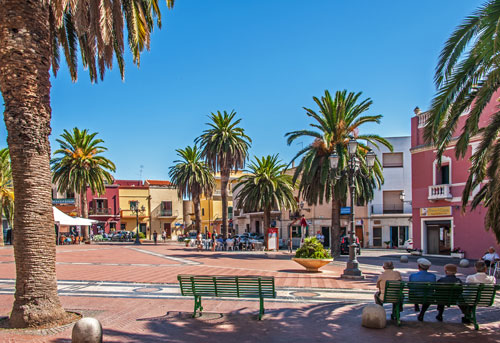
The central point of the town is the palm-lined Piazza Umberto (photo). From here, all the sights are conveniently reachable on foot.
Basilica Sant’Antioco Martire
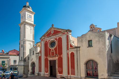
The parish church stands a bit above the Piazza Umberto.
The original construction from the 6th century has been altered several times.
It is named after Saint Antioco (Antiochus) of Sulci. He was a physician who spread Christianity during the 2nd century under Emperor Hadrian and was sentenced to forced labor in the island’s mines as a result.
According to legend, he clandestinely erected an underground chapel, was subsequently sentenced to death, and executed.
Underneath the church lie Punic burial chambers, which were converted by the Christians into catacombs, tunneling under almost the entire city to this day.
Some of them can be visited; the entrance is located within the church.
Forte Su Pisu (Forte Sabaudo)
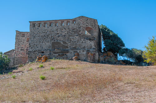
The small fort stands on a hill overlooking Sant’Antioco.
Construction began in 1813. Despite receiving a letter from the House of Savoy in July 1814 urging the completion and staffing of the fortress, the construction was still unfinished after two years.
On October 16, 1815, fifteen Tunisian ships approached. Over a thousand corsairs landed on the island and advanced into the city center. The inhabitants fled to the hinterland, while the small fortress was defended only by its commander, sixteen soldiers, and a few civilians.
After seven hours, the attackers were able to storm the fort and abducted 158 people into slavery in Tunis.
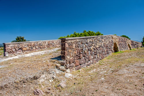
Necropolis and Tophet

From the fortress hill, the large excavation site is well visible.
The hill is crisscrossed with numerous tunnels and chambers where the Punics and Phoenicians buried their dead.
Under Roman rule and the beginning of Christianization, the site was initially still in use.
Above the necropolis, the sparse ruins of the Punic acropolis can be seen.
A bit further downhill lies the Tophet, where numerous urns containing ashes have been found. Roman and Greek sources report children being sacrificed by the Phoenicians and Punics at such places. However, this theory is now doubted by experts.
The fortress, necropolis, and Tophet can only be visited as part of a guided tour.
Ponte Romano
The remains of the Roman bridge lie outside the city. If you’re driving onto the island, you’ll pass by it shortly after the causeway (see map). The bridge is among the few purely Roman relics preserved in Sardinia.
The small islands in the strait allowed a connection between the island of Sulci and the mainland. It is believed that the roads and the opening of a channel date back to the Phoenicians.
Later, the Romans erected a bridge with two arches over the original channel, which is now submerged in the earth. The remnants of the ancient roads connecting the bridge to the isthmus are no longer visible today.
Over the course of several centuries, the bridge was restored multiple times. It was called “Ponti Mannu” (Big Bridge) because it was the largest bridge among all connections between the various small islands, the mainland, and Sant’Antioco.
Calasetta

Calasetta is located on the northwest side of the island of Sant’Antioco. The town began to take shape from the year 1770 when, under King Charles Emmanuel III, Ligurian refugees were allowed to settle there. They had previously lived in a trading post in Tunisia but were forced to flee.
Calasetta is not a typical Sardinian small town. It was planned by military engineer Pietro Belly, resulting in a layout of straight streets in a grid pattern.
The main sources of income are tourism and agriculture. The palm-lined pedestrian zone of Via Roma (photo) is the promenade of the town and ends directly in front of the town hall.
The town offers a pleasant, bright, and tranquil atmosphere.
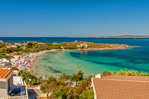
From Piazza Municipio in front of the town hall, a narrow street leads up to a fortress-like watchtower. This tower was built by the Savoyards in 1756/57. Later, it became the founding site for the emerging Calasetta.
Below the tower lies Calasetta’s main beach, Spiaggia Sottotorre (photo). Additional beaches can be found along the west coast heading south.
During the season, all beaches are very crowded, and parking spaces are scarce.
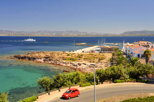
In the port of Calasetta, there is a regular ferry connection to Carloforte, the main town of the neighboring island of San Pietro.
Carloforte was established approximately 30 years earlier than Calasetta and was also built by Ligurian refugees who had to leave their settlement in Tunisia.
In both towns, the Genoese dialect is still spoken to this day.