Destination Sardinia
  • The island
    • History
    • Regions
    • Points of interest
    • Climate
    • Geography
    • Nature
    • Beaches
    • Festivals
    • Language
  • Travel time
  • Arrival
    • Car/Motorbike
    • Ferry
    • Plane
    • Train
  • Accommodation
    • Hotel
    • Bed and Breakfast
    • Holiday flat
    • Holiday house
    • Agriturismo
    • Camping
    • Campervan
  • Food and Drinks
    • Eating out
    • Self-catering
    • Culinary specialities
  • Mobility
    • Car
    • Motorbike
    • Bike
    • Bus
    • Railway
    • Ship and boat
  • Points of interest
  • Activities
    • Hiking
    • – Tour tips
    • Climbing
    • Surfing
    • Diving and snorkelling
    • Fishing
    • Riding
  • Pract. tips
    • Literature
    • Maps
    • Language
    • Post and telephone
    • Internet
    • Opening hours
    • Photography
    • Children
    • Health
    • Dogs and pets
    • Souvenirs
    • Weblinks
  • Menu Menu
  • The island
    • The island
    • History
    • Regions
      • Anglona/Turritano
      • Arborea
      • Barbagia
      • Baronia
      • Cagliari region
      • Campidano
      • Gallura
      • Iglesiente/Sulcis
      • Logudoro/Meilogu
      • Nurra
      • Ogliastra
      • Planargia
      • Quirra/Sarrabus
      • Sarcidano/Marmilla
    • Points of interest
      • Alghero
      • Alghero, north
      • Archipelago di La Maddalena
      • Ardara / Sant‘ Antioco di Bisarcio
      • Argentiera / Grotta di Nettuno
      • Aritzo
      • Arzachena and surroundings
      • Bosa
      • Burgos and surroundings
      • Cagliari
      • Capo Comino / Spiaggia di Berchida
      • Carbonia and Monte Sirai
      • Castelsardo and surroundings
      • Churches near Sassari
      • Costa del Sud
      • Costa Rei and hinterland
      • Costa Smeralda, Palau and surroundings
      • Costa Verde
      • Fonni and surroundings
      • Fordongianus
      • Giara di Gesturi
      • Gola su Gorroppu / Codula di Luna
      • Gulf of Orosei
      • Iglesias and Grotta di San Giovanni
      • Ingurtosu
      • Isola di Sant’Antioco
      • Is Pirois, Funtana Coberta, Pranu Muteddu
      • Ittireddu
      • Macomer and surroundings
      • Montiferru-Area
      • Nebida, Masua and Buggerru
      • Nora
      • Nuoro and surroundings
      • Nuraghe Arrubiu
      • Nuraghe Iloi and surroundings
      • Nuraghe Losa
      • Nuraghe Santu Antine / Sant‘ Andria Priu
      • Nuraghe Su Nuraxi
      • Olbia and surroundings
      • Orgosolo
      • Oristano / Sinis-Peninsula / Tharros
      • Orosei and Biderosa Nature Park
      • Orosei’s hinterland
      • Osini and Ulassai
      • Ozieri
      • Porto Torres and Monte d’Accoddi
      • Posada and Surroundings
      • Sadali
      • Santa Cristina
      • Santa Teresa / Capo Testa
      • Santa Vittoria
      • Sassari and Noeddale Necropolis
      • Sedini and Martis
      • Siniscola and Surroundings
      • Stintino and Isola Asinara
      • Su Golgo, Sa Pedra Longa, Santa Maria Navarrese
      • Su Romanzesu and Nuraghe Loelle
      • Su Tempiesu and Nuraghe Noddule
      • Tempio di Antas
      • Tempio Pausania and Surroundings
      • Tonara, Sorgono, San Mauro, Menhire Biru ‚e Concas
      • Trenino Verde (Arbatax-Sadali)
    • Climate
    • Geography
    • Nature
    • Beaches
    • Festivals
    • Language
  • Travel time
  • Arrival
    • Arrival
    • Car/Motorbike
    • Ferry
    • Plane
    • Train
  • Accommodation
    • Accommodation
    • Hotel
    • Campervan
    • Agriturismo
    • Bed and Breakfast
    • Camping
    • Holiday house
    • Holiday flat
  • Food and Drinks
    • Food and Drinks
    • Eating out
    • Self-catering
    • Culinary specialities
  • Mobility
    • Mobility
    • Car
    • Motorbike
    • Bike
    • Bus
    • Railway
    • Ship and boat
  • Points of interest
    • Alghero
    • Alghero, north
    • Archipelago di La Maddalena
    • Ardara / Sant‘ Antioco di Bisarcio
    • Argentiera / Grotta di Nettuno
    • Aritzo
    • Arzachena and surroundings
    • Bosa
    • Burgos and surroundings
    • Cagliari
    • Capo Comino / Spiaggia di Berchida
    • Carbonia and Monte Sirai
    • Castelsardo and surroundings
    • Churches near Sassari
    • Costa del Sud
    • Costa Rei and hinterland
    • Costa Smeralda, Palau and surroundings
    • Costa Verde
    • Fonni and surroundings
    • Fordongianus
    • Giara di Gesturi
    • Gola su Gorroppu / Codula di Luna
    • Gulf of Orosei
    • Iglesias and Grotta di San Giovanni
    • Ingurtosu
    • Isola di Sant’Antioco
    • Is Pirois, Funtana Coberta, Pranu Muteddu
    • Ittireddu
    • Macomer and surroundings
    • Montiferru-Area
    • Nebida, Masua and Buggerru
    • Nora
    • Nuoro and surroundings
    • Nuraghe Arrubiu
    • Nuraghe Iloi and surroundings
    • Nuraghe Losa
    • Nuraghe Santu Antine / Sant‘ Andria Priu
    • Nuraghe Su Nuraxi
    • Olbia and surroundings
    • Orgosolo
    • Oristano / Sinis-Peninsula / Tharros
    • Orosei and Biderosa Nature Park
    • Orosei’s hinterland
    • Osini and Ulassai
    • Ozieri
    • Porto Torres and Monte d’Accoddi
    • Posada and Surroundings
    • Sadali
    • Santa Cristina
    • Santa Teresa / Capo Testa
    • Santa Vittoria
    • Sassari and Noeddale Necropolis
    • Sedini and Martis
    • Siniscola and Surroundings
    • Stintino and Isola Asinara
    • Su Golgo, Sa Pedra Longa, Santa Maria Navarrese
    • Su Romanzesu and Nuraghe Loelle
    • Su Tempiesu and Nuraghe Noddule
    • Tempio di Antas
    • Tempio Pausania and Surroundings
    • Tonara, Sorgono, San Mauro, Menhire Biru ‚e Concas
    • Trenino Verde (Arbatax-Sadali)
  • Activities
    • Activities
    • Hiking
    • – Tour tips
    • Climbing
    • Surfing
    • Diving and snorkelling
    • Fishing
    • Riding
  • practical tips
    • practical tips
    • Literature
    • Maps
    • Language
    • Post and telephone
    • Internet
    • Opening hours
    • Photography
    • Children
    • Health
    • Dogs and pets
    • Souvenirs
    • Weblinks
  • Search…
You are here: Home1 / The island2 / Points of interest3 / Gola su Gorroppu / Codula di Luna

deutsch

Gola Su Gorroppu / Codula di Luna

map of both canyons

Gola Su Gorroppu

Wanderung vom Genna Silana zur Gola su Gorroppu

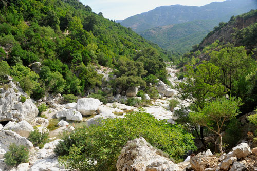
Here, the Riu Flumineddu has created a huge gorge that is one of the deepest in Europe. The walls rise vertically up to 400 metres.

There are basically two ways to get here:

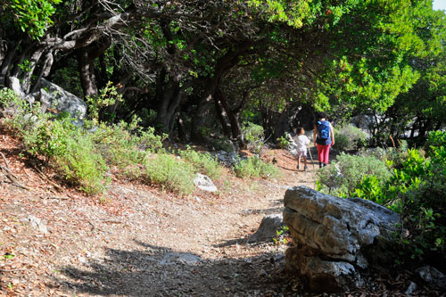
1. The more strenuous but scenically more various version starts at the Genna Silana pass.
Here, the route first leads through sparse holm oak forests and later steeply downhill into the river valley.
There is an altitude difference of 600 m to overcome. Especially the way back requires a lot of stamina.
You should plan in total 5 hours for the tour (2 hours for the way there and 3 hours for the return).

Gola su Gorroppu, Wanderung im Flußtal

2. The easier tour, which can also be done with children, starts at the bridge “Ponte S’Abba Arva” in the south of Dorgali.

The approach from Dorgali is only sporadically signposted. It is best to take the turn-off from the SS 125 which starts about 1 km south of the tunnel to Cala Gonone. (see map)
The narrow road is asphalted throughout. It descends steeply and winds along vineyards and olive groves for 10 km to the car park.

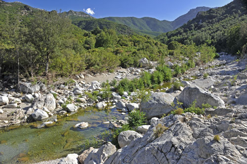
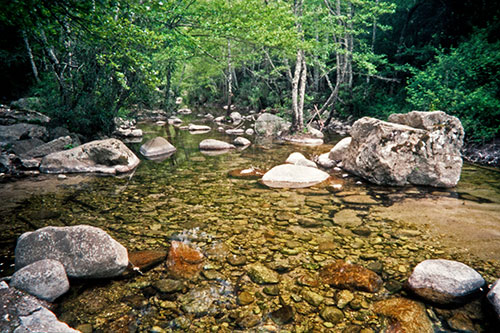
The trail follows the course of the Riu Flumineddu river, whose waters come to the surface again and again, even in summer, and invite you to bathe.
The hiking to Gola su Gorroppu takes 1.5 – 2 hours. There are no major inclines to overcome.

Gola su Gorroppu, Gumpen

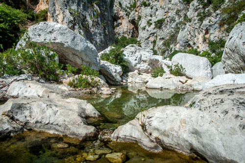
Below, at the entrance to the gorge, the water of the river emerges from between the limestone rocks and forms several pools with wonderfully clear, cool water.
Especially for children it is a great experience to swim here.

However, the water level in the pools is very dependent on previous rainfall. In dry summers, you should not expect too much here.
As an alternative, there are still the water holes in the Riu Flumineddu on the way back to Ponte S’Abba Arva.

Gola su Gorroppu, Klettern in der Schlucht

In the meantime, an entrance fee is charged at the entrance to the gorge (at least in the high season). Afterwards you will receive a short briefing about the course of the path and learn interesting facts about the gorge.
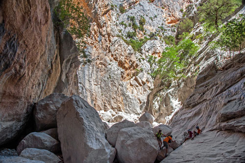
The path is marked in the initial part, and further back there are climbing aids at difficult places. This makes access much easier.
The level of difficulty increases the further you go. At first you simply follow the green dots on the rocks. Later, there are increasingly larger boulders to overcome (photo).
The last section requires climbing experience and a lot of stamina. This part of the gorge is actually only intended for guided tours.
The rocks are often very slippery, so that you can hardly find a foothold with normal hiking boots. Walking alone is therefore not advisable.

Gola su Gorroppu, AusgangThe sun only shines into the valley in the morning and midday hours. Later on the whole area is shady and the air can be quite fresh then.
It is best to take the whole day for this excursion.

You can use the morning hours for photography because of the better light. The hot midday hours are best spent in the shade and in the pools.
For the way back, you should wait until the temperature has become bearable in the afternoon, especially in summer. Otherwise the ascent to Genna Silana quickly becomes a torture.

Again, take at least 2 litres of drinking water per person!
There are no catering facilities on either route.

The dimensions of the gorge cannot be properly captured in photos. Chris Lemke of Bergwasser Canyoning & Rafting has made a wonderful video (in German) showing the Gola su Gorroppu from different perspectives:

Codula di Luna

Codula di Luna, oberer Teil

This gorge is one of the most beautiful in Sardinia and can be walked all the way to the sea.
You can reach the entrance to the gorge by leaving the SS 125 at km 172 in the direction of “Loc. Teletotes”.
The narrow road is asphalted throughout and easy to drive on, but is not marked on all Sardinia maps.
After about 12 km the road ends. From here, you have to continue on foot.
Orientation in the gorge is relatively easy – just follow the course of the Riu Codula di Luna. Along the way, the river forms small pools that invite you to swim.
The path is very flat all the way, there are no major differences in altitude to overcome.

Codula di Luna, unterer Teil

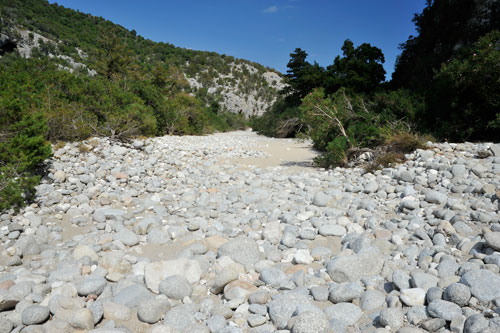
During the hot season, the Riu Codula di Luna has only little water and disappears repeatedly under the scree.
In the lower part, the hiking then becomes quite strenuous. There is no longer a real path. For long stretches you have to walk on the river bed, because everything is overgrown with dense macchia on the sides.
Above all, it is important to take enough drinking water with you! The restaurant at Cala di Luna is only open in the warm months.

Codula di Luna, Ausgang an der Cala di Luna

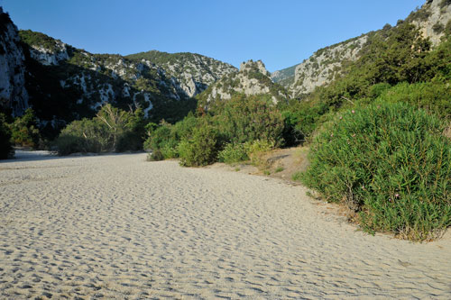
Shortly before the coast, the ground becomes sandy, which makes it very difficult to move forward in places. The vegetation becomes even lusher.
The gorge here passes bizarre rock formations that invite you to climb.

If you only want to make a short detour into the Codula di Luna and the organisational effort of a complete hike through is too much for you, then a day trip to Cala di Luna is also an option.
From here, you can entry into the gorge and combine the whole trip with a wonderful day of swimming. In this case, I recommend taking a boat to Cala di Luna and back, because the stretch from Cala Gonone is quite strenuous on foot.

Blick zur Cala di Luna

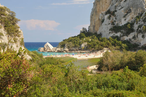
The hiking from Teletotes to Cala di Luna takes about 4 – 5 hours.

At Cala di Luna (photo) you have the following options:

  1. If you are fit enough, return to your vehicle along the same path.
  2. Continue walking to Cala Gonone (about 2.5 hours) and from there take a second vehicle to Teletotes.
  3. You go to Cala Gonone by excursion boat. This option requires a reservation in advance. In the low season there are only a few boats and in the high season they are all booked up to the last seat.

Search Search

Instagram

Follow us

Legal Notice

Legal Notice

Privacy Policy

Privacy Policy

Contact

Contact

© Copyright Traumziel-Sardinien 2009-2026
Scroll to top Scroll to top Scroll to top