![]()
Su Romanzesu and Nuraghe Loelle
map of Su Romanzesu with the marked sights
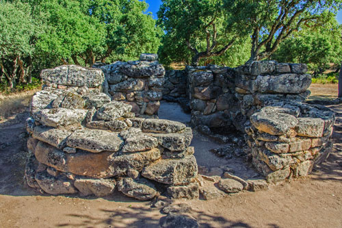
Su Romanzesu Sacred Well
 The site was discovered by accident while searching for water and was first described in 1919. The most significant excavations were carried out in the 1980s. It is estimated that only 20% of the entire complex has been uncovered.
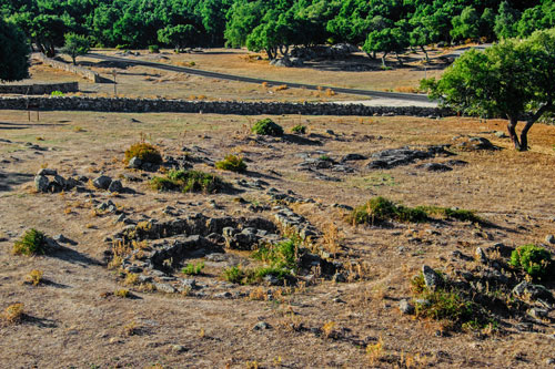
The complex covers an area of about 7 hectares and is situated in the middle of an extensive cork oak forest. It must have been an important sanctuary during the Nuragic period, where religious rites and cults related to water were celebrated. The structures were built during the Bronze Age between the 16th and 8th centuries BC.
Unfortunately, during renovations in the 1920s, the original spring was redirected and partially destroyed.
However, the remains of the sacred well with its tiered seating, several temples, and round huts are well preserved.
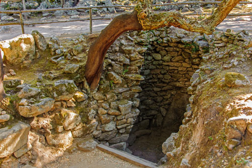 The well served as a catch basin for the spring water.
It was covered by a so-called Tholos roof, which is still preserved up to a height of 3.60 m today.
During heavy rains, the well overflowed, and the water was initially channeled to two collection basins.
From here, it flowed between granite walls to the large basin.
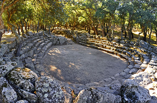
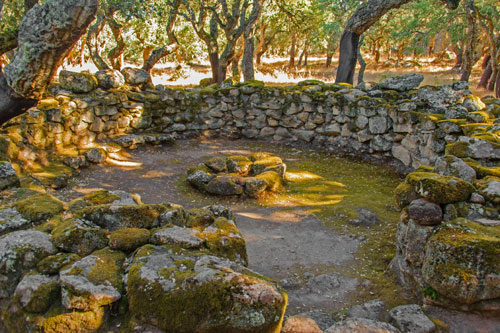
The large ceremonial basin is about 40 m from the well. It has the shape of an amphitheater and was probably used for the ritual baths of the Nuragic people.
Both the channel and the basin are surrounded by tiered seating.
Above the channel, there are two Baetyls, vertically standing granite stones meant to represent deities and associated with fertility rituals.
Although the Nuragic people revered water as sacred throughout the island and built numerous sacred wells, this complex is unique in its form in Sardinia.
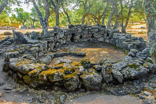
Around the sanctuary, the foundations of about 100 round huts are still standing. These huts were typical of the Nuragic culture.
The floor was paved with stones, and a central hearth was located in the middle. The conical roof was made of wooden poles and covered with branches.
Some of the larger huts have built-in benches and were probably used as assembly rooms. Most were residential buildings for the village community and accommodations for pilgrims.
The first Nuragic settlement emerged during the Middle Bronze Age in the 16th century BC. It wasn’t until about 300 years later that the sacred well and other religious buildings were constructed. The village then developed into a sacred site and pilgrimage center.
Three so-called Megaron temples have been discovered in Su Romanzesu so far. The term Megaron derives from the typical rectangular construction with extended exterior walls.
Only 20 temples of this type are known on Sardinia – the fact that three of them are located here highlights the importance of the site.
The largest and best-preserved Megaron temple dates back to the 14th century BC. It was subsequently expanded and remodeled several times.
Inside the temples, numerous ceramics and bronze objects were found, as well as parts of amber necklaces. This amber find, consisting of 153 beads and many fragments, is the largest discovered on Sardinia to date.
How to get there: You can reach Su Romanzesu from the SS 389. (see map) The well-signposted turnoff is located between Bitti and Buddusò, around km 54. From here, a narrow but fully paved road leads 2.6 km through a beautiful cork oak forest to the visitor center.
Nuraghe Loelle
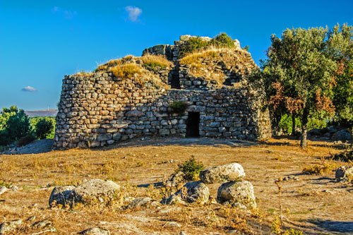 This impressive structure is a mixed type of Nuragic architecture. It combines elements of both Corridor and Tholos Nuraghe.
The site is freely accessible.
The main tower is surrounded by an additional fortification with several passageways and chambers.
You can climb up the passageways and stairs to the top level. From there, you have a beautiful view over the plateau and the surrounding cork oak forests.